This is an article I wrote with Saskia de Wit for Footprint on metropolitan form – an underrated topic in the spatial disciplines but one which landscape has a lot to offer.
Much of what contemporary urban form is today, exceeds the comprehension of the conventional urbanism and architectural repertoire. The distinctive physical characteristics of the city and its districts have been replaced by an urbanised field made up of indistinct, fragmented territories. The spatial character of these urban fields clashes with ideas of harmony, co-operation and order to be found in traditional urban models. Through the lens of the Metropolis however, much of what is not clear about this new urban condition can be qualified. The metropolis is an unstable, dynamic environment in which elements of the contemporary city re-array themselves in an urban-landscape system. Ordering, composing and acting in this system places a new responsibility on landscape. To what extent landscape, in the sense of the permanent underlying substructure, or visual, physical and conceptual open space and as a conceptual and instrumental ‘vehicle’ of nature, has a bearing on the elaboration of the metropolitan repertoire is the broader field of inquiry of the research programme of Landscape Architecture in Delft. The overall intention of the research is qualitative; it is guided by primary objectives of the spatial design disciplines: the understanding, definition and development of spatial quality. The aim is to distil instruments from both the landscape ‘lens’ and the underlying landscape itself, in order to replace or add to the classical understanding of city form, given its increasing shortcomings in dealing with the contemporary spatial problematique.
In this paper the dissection of the landscape-architectonic treatment or ‘action’ and the discovery of archetypes derived from landscape-architectonic practice are explored.
A first step in reaching an alternative metropolitan repertoire is the redefining of landscape-architectonic archetypes for metropolitan transformations in abstracted spatial terms, removed from scale, programme and meaning. In 1995 Clemens Steenbergen, Wouter Reh en Peter de Zeeuw laid down a tentative theory in order to describe new urban territories in abstract terms, reducing contemporary urbanisation patterns to points, lines and planes. This resulted in three basic forms: the flow landscape, the plantation and the landscape theatre. (( Clemens Steenbergen, Wouter Reh, Peter de Zeeuw, Landschapstransformaties (Delft: Delft University Press, 1995), pp. 64-73. )) The potential of this theory for the contemporary metropolis is significant, but its elaboration and testing has to date received little attention. In this paper we intend to scrutinise these basic forms and place them in the perspective of the development and discourse of the metropolis.
Viewing urban history from a landscape-architectural point of view we can define a sequence of moments from which the archetypes for these basic forms are derived. Studying the successive stages we can discern four conditions for the development of a comprehensive urban-landscape system in a formal and spatial sense. In the metropolis the different stages, conditions and forms will usually overlap in space and time, as a result of which combinations and confrontations of landscape-forming forces that give a special dynamic to the metropolitan landscape architecture can be generated. Placed in an historical perspective, the development of the metropolis can thus be understood as a logical progression away from the notion of city as artefact and towards the city as landscape. In addition, spatial archetypes grounded in landscape architectonic practise can be shown to emerge out of this development.
The interplay between the basic forms can breach the scales defining the landscape and endow the metropolis with architectural form. The next step involves finding motives from which we can distil models for the staging of the metropolitan composition. These models are vital tools in the choreography of the metropolitan landscape and can be found within the landscape itself. When the city disintegrates into an archipelago of fragments a new role is also imposed on the landscape as a carrier of topographical characterisations, cohesion and continuity. The underlying landscape layer contains an annotated catalogue of situations, in which the genius loci is recorded and secured. These latent compositional elements can be transformed into landscape architectural compositions within the topography of the emerging metropolis.
Three cases will assist to highlight the role of these basic forms in the discourse of the metropolis as a compositional problem: Los Angeles, widely recognised as a textbook metropolis, the Randstad, where the concept of the metropolis is mainly seen as an unfulfilled task, a ‘possible transformation from the current loose collection of villages, towns and cities in the delta of the Rhine and the Meuse into a coherent urban system of stature, a European metropolis’, (( Dirk Frieling, ‘Inleiding, opzet/methode ’ in: Onderzoeksatelier Deltametropool: Strategische Rol van het Ontwerpen (Delft: Delft University Press, 2001), p. 8. )) and the metropolitan area of Hampstead Heath in London.
The metropolis as a compositional problem
Through all of urban history, from Jericho to Marne-la-Vallée, it has been common practice in the perception of the city to view the city as a whole, no matter what concept to describe the city is used. The different concepts can be categorised into three ‘normative’ models, as Kevin Lynch analysed in his book Good City Form: the cosmic model, the city as a spatial diagram of social hierarchy as an interpretation of the universe; the practical model, or the city as a machine, a functional construct of interrelated parts; or the organic model, an indivisible, living organism. (( Kevin Lynch, A Theory of Good City Form (Cambridge, Mass./ London, 1973), pp. 73-98. )) What these models have in common is that the city is always viewed as a whole, as an artefact placed against the background of the non-city, determined by the way it is distinguished, separated from its environs. ‘The city always assumes another (outside) world, that of the landscape in which the ideal image of the city can be projected. The historical footprint of the city is a definite limited space in an indefinite, limitless landscape.’ (( Clemens Steenbergen, ‘Metropolitan Footprints’, in: The Architecture Annual 2006-2007 ed. by H. Bekkering et. al. (Rotterdam: 010 Publishers, 2008), p. 110. ))
In contrast to the territorially limited city is the concept of the metropolis: an unstable, dynamic environment in which elements of the contemporary city re-array themselves in an unbounded urbanised territory. The spatial character of these territories clashes with ideas of harmony, co-operation and order to be found in traditional urban models. In western cultures, these models stem from a collective ‘consciousness’ of the ideal form of city and landscape and are rooted in historical precedents. Continuity and harmony are the primary ingredients of utopias and these continue to qualify our ideas of urban space. In metropolitan territories, the continuity and composition of the classical city would appear to be replaced by a contiguity of urban forms: a stacking of programmatic entities side-by-side. (( Lars Lerup, After the City (Cambridge: MIT Press, 2000). )) Several design theories and models dealing with contiguity have seen the light of day. In his analysis of the transformation of the urban fringe of The Hague, Neutelings depicts the metropolitan territory as a carpet of urban fragments devoid of compositional form. (( Willem-Jan Neutelings et. al., ‘De transformatie van de Haagse Stadsrand: De Randstad als Ruimtelijk-Programmatisch Tapijt’ in: Stadsontwerp in ‘s-Gravenhage, (Delft: Delft University Press, 1989). )) The continuity and compositional logic of the city is argued to have been replaced by a contiguity of elements and networks in the metropolis. OMA’s scheme for the Parc de la Villette competition in 1982 proposed contiguous banding and layering as an alternative to compositional continuity and formal and spatial ensembles and was inspired by similar conclusions about metropolitan form. (( Rem Koolhaas and Bruce Mau, ‘Congestion Without Matter’ in: S, M, L, XL (Rotterdam: 010 Publishers, 1995), pp. 895-943. ))
The apparent non-compositional contiguity of metropolitan territories however, can be shown to be relative to the context within which the territory is perceived. Within the context of an (architectonic) language of composition rooted in utopian city models, they can be considered lacking in compositional continuity. Within the context of an architectonic language rooted in landscape practise however, they can be seen to be compositional, or composable. The evolution of the metropolis away from the notion of city as artefact and towards the city as landscape defines this difference.
The evolution of the metropolis
The change from a city in the landscape to the city as a landscape of fragments is generally considered a contemporary development. When viewed as a collection of landscape-architectonic transformations however, the metropolis may be considered as a city that has gradually opened up to the landscape, on all scales and in different forms over a much longer period of time. The development from the Western-European medieval city to the present-day metropolis can be broken up in four stages of the spatial and architectonic ‘opening-up’ of the city. (( Clemens Steenbergen, ‘Metropolitan Footprints’, in: The Architecture Annual 2006-2007, ed. by H. Bekkering et al. (Rotterdam: 010 Publishers, 2008), pp. 114-115. )) This classification is not aimed at a complete historical overview or at a historical classification of the large variety of landscape-architectonic elements, but at the distinction of essential steps and prototypes that drive the metropolitan process. Each stage plays its own role in the spatial definition of the city-landscape relationship. Each can be viewed as an addition to the formative ‘force-field’ of the metropolis, leading to a comprehensive urban-landscape system as a spatial and formal composition.
In the medieval city primordial urban landscapes, such as the town garden or vegetable garden as a private domain and the garden as a public space or cemetery next to churches or institutes, formed the stepping stones in the functional relationship with the landscape and with nature. Beyond the city walls the city meadow, the archers’ field, the bowling alley and the menagerie formed their counterparts in this relationship, as elements of leisure and entertainment. From the Renaissance onwards, the landscape territory of the city was opened up architecturally and new urban landscapes were created, such as the villa, forecourt, botanical garden, plantation, square, city walk and city woods. This could be viewed as the first stage of the metropolitan process: the introduction of an Arcadian territory in the form of a country-estate landscape in the urban hinterland. (( Clemens Steenbergen and Wouter Reh, Architecture and Landscape: The Design Experiment of the Great European Gardens and Landscapes (Berlin, 2003), pp. 20-21. )) [Fig. 1]

Fig 1: Landscape and Metropolis phase 1
During the course of the 19th century the city perimeter gradually dissolved, opening up the city to the surrounding landscape. The expansion of the modern city into this landscape came about using a new repertoire of landscape-architectonic typologies. As compensation for industrial exploitation, nature was elevated to a separate cultural category. This resulted in the invention of parks, such as the public park, the national park and the nature reserve, in which the cult of nature could be celebrated. The city park was included in the city in a planned manner, as ‘artificial nature’ and as public facility. It was given form through a series of experimental transformations of the English landscape garden. Reconsidering the position of the house and organising it serially could transform the landscape garden into a villa park, a common landscape-based form of living in the city. Through an intensification and differentiation of the routing system the landscape garden could be transformed into a public promenade park, which integrated in an organic manner into the street grid of the city. Through the defining and differentiation of the programme the landscape garden could be transformed into a public park as the centre of urban recreation in nature. Thus the expansion of the open city into the landscape, the opening up of the city perimeter with the city park as a colonisation model, can be distinguished as the second stage of the metropolitan process. [Fig. 2]

Fig. 2: Landscape and Metropolis phase 2
By considering the public park as a link in a series or as a potential framework for new urban expansion, the park system, the parkway and the park city came into being. In the 20th-century garden city the public green appeared as an ‘interim space’ and remedy for the increasingly inaccessible landscape. Programmatic and ecological aspects were mutually cohesive. The programme of this structure artificially encompasses the ‘entire’ landscape with, among other things, the allotment, the playground, the sports fields and the cemetery. The green belt was a last heroic effort at keeping the city organised and the landscape accessible. As an unformed buffer zone without an architectonic strategy this green belt marks the boundary of the urban landscape as a landscape-architectonic intervention. This makes the implosion of the city perimeter and the transformation of a continuous urban grid or street system into a series of urban islands the third stage of the metropolitan process. The process of fragmented urban expansion goes hand in hand with the formation of interim landscapes. [Fig.3]

Fig. 3: Landscape and Metropolis phase 3
When, as a result of the continuous process of urban expansion and transformation the entire territory ultimately disintegrates and the city becomes poly-nuclear, the difference between city and landscape vanishes. The fourth stage of the metropolitan process can therefore be described as the disappearance of the distinction between city and landscape. City and landscape are united in an ‘unlimited’ urban field of hybrid intermediate forms. [Fig. 4]

Fig. 4: Landscape and Metropolis phase 4
Basic landscape forms
In the opening up of the city, landscape-architectonic archetypes emerge that are unmistakably urban but at the same time belong to the landscape, the non-city. They don’t have a place in the dichotomy of city versus non-city, but are already giving shape to the comprehensive urban-landscape system of the emerging metropolis. Reduced to their formal and spatial properties they constitute basic or archetypal forms that also qualify the spatial condition of the present-day metropolis. The city walks, parkways and the green structures of the 20th-century expansion plans are linear structures with a narrative structure, ‘that bead living, working and infrastructure into a bold visual story’. (( Ed Taverne, ‘Randstad Holland: Horizons van een Verstrooide Stad, Archis, 7 (1994), 42. )) More than just a feat of engineering, these infrastructural lines are seen as a cultural phenomenon where movement is the motor of a physical and visual experience. The view from the road and its position in the landscape are inherent to the traffic artery. Together they constitute a flowscape. [Fig. 5]

Fig. 5: Basic forms: flowscape.
The different urban forms that emerged through time, from the compact medieval city to the functionally and spatially autonomous urban islands, can be seen as forms of a colonisation grid with an ordering principle based on the urban programme of dwelling, work and leisure, plantations. [Fig. 6]

Fig 6: Basic forms: plantation.
In contrast, the medieval public gardens as well as the public parks, the national parks and the nature reserves, the allotments, sport fields and cemeteries are architectonic fragments, defined spaces, voids, where the natural processes are exposed and the landscape horizon is inverted to an internal horizon, perceivable at any scale. Their spatial staging, based on the relationship between the spectator and the spectacle, refers to the theatre; they can be viewed as landscape theatres. [Fig. 7]

Fig 7: Basic forms: theatre.
Through the visor of this dissection of the landscape-architectonic treatment or ‘action’, the discovery of archetypes that are derived from landscape-architectonic practice, we will view two examples that play a role in the current metropolitan discourse, in order to deepen the understanding of these basic forms and test their usefulness for the understanding and design of the metropolitan space and scale. Los Angeles, with its unbridled urban sprawl, inconsequential architecture, freeways, sun, surf and smog is the prototypical metropolis, or at least one of them. One of the most evocative descriptions of the relationship between metropolis and landscape is Reyner Banham’s pioneering architectural study of Los Angeles in 1971. (( Reyner Banham, Los Angeles: the Architecture of Four Ecologies (London: Allen Lane The Penguin Press, 1971). ))
The first settlement was founded at the place where the river valley of the Los Angeles River opened up to the Pacific. At first the sandy coastal plain was divided into ranches for cattle rearing with areas of wilderness left as public lands. Soon afterwards however, the colonisation grid for which Thomas Jefferson had laid the foundation in the Land Ordinance Act (1785) – a large-scale framework for agricultural and urban development – was rolled out over the continent. The ranchos were replaced by a network of roads, railways and aqueducts, containing a manifold repetition of the homestead, the detached American house with its surrounding yard. In 1848 the frontier of the New World reached the West Coast and Los Angeles, which at that time had 2,500 inhabitants. It grew into a ‘suburb’ with 1 million inhabitants by 1915; a ‘super-urb’ of 17 million inhabitants by 2003.
Banham decomposed this super-urb into four different contextual fabrics, ‘ecologies’ in his words: mountains, plains, beaches and freeway. There are no urban hierarchies to be found here, as becomes clear from his reading of the ecologies. Although Los Angeles is situated on one of the world’s most beautiful beaches, the ‘greatest City-on-the-Shore’, it is not a seaside city. It was not entered or conquered from the sea, nor has it a very important port. Its genesis lies inland, a foundation that suddenly began to leapfrog towards the sea in the railway age, creating a string of seaside suburbs. And although the original settlement is at the edge of the valley and the hills, and extended rapidly uphill, the main extension remained sensibly on the flattish valley-bottom. This valley-bottom determines the world’s image of Los Angeles – an ‘endless plain endlessly gridded with endless streets’. (( Reyner Banham, Los Angeles: the Architecture of Four Ecologies (London: Allen Lane The Penguin Press, 1971), p. 161. )) . Paradoxically, this is also the area where Los Angeles is least distinctly itself, and the image is countered by its images of component parts like Hollywood or Malibu. The fourth ecology, the freeway system, is not just a transportation mode, serving the other ecologies but a single comprehensible place in its own right, dictated by a unified system of freeway signs, and deeply ingrained in the psychology of the Angeleno. The fabrics of Banham’s metropolis underline not only a fundamental relationship between urban form and an underlying landscape condition, they also hint at the development of compositional elements – basic forms – constituting a new metropolitan composition.
If the metropolis is a generic condition, then its basic forms should be discernable in some form or other in other metropolitan areas; a landscape ‘vivisection’ of the European metropolis should yield similar archetypal basic forms as those in Los Angeles. The second example, the Randstad, although researched widely in those terms, is questionable as an example of a metropolis. Politicians, geographers and architects still doubt its mere existence. (( Ed Taverne, ‘Randstad Holland: Horizons van een Verstrooide Stad’, Archis, 7 (1994), 27-51. )) As an urban agglomeration however, with a loose collection of villages, towns and cities gathered around open polder lands of the Dutch Lowlands and joined by a dense network of infrastructure, it increasingly demonstrates spatial phenomena typical of metropolitan territories. If we want to get a grip on the formal problem of an emerging metropolis that becomes visible here, we should not view this agglomeration in the traditional formal images based on a categorical distinction between ‘red’ and ‘green’, nor in a holistic view of landscape and city in a complex interrelation. An elementary investigation of the landscape-urban system is instrumental. (( Wouter Reh, ‘Het Stedelijk Landschap als Tijd-Ruimtestelsel: Naar een Architectonisch Management van Ruimte en Tijd’, in Deltametropool: Tijd als Instrument van Ordening (Delft: Delft University Press, 2000), p. 90. ))
The western zone of the Randstad, defined by the conurbation of Utrecht, Nieuwegein and Houten is chosen as a case study area.
Flowscape
The motorway landscapes of the Randstad have long since displayed an ‘otherness’ in comparison to other urban territories in the Netherlands. A cocktail of stringent environment legislation, market forces and administrative divisions has resulted in unprecedented development along the motorway network of the Randstad since the 1970s.
Added to this, the decision in the National infrastructural plan (Structuurplan Hoofdwegennet) in 1966 to bypass urban cores when building new highways created the ideal spatial conditions for a new form of urbanisation. Although functionally drawn towards the motorway, the morphology of Dutch cities clashed with the morphology of the motorway zone. From the 1970s onwards the flanks of the motorway became progressively separated from their urban context; although integral to the spatial network of the city, they made no substantial contribution to it. Moreover, urban functions such as housing and recreation didn’t mix well with highway noise and pollution. This increasing estrangement from the city (and the landscape) left the repertoire of Architecture and Urban Design – grounded in the static enterprise of the traditional city – high and dry. With some notable exceptions – the Zuid-As in Amsterdam and Leidsche Rijn to the west of Utrecht – the zone was more or less left to its own devices. This condition now defines the majority of motorway corridors in the Randstad area. (( René van der Velde, ‘Supertype’, in: A12 Nu: Onderzoek naar de A12 zone tussen Utrecht, Nieuwegein en Houten (Rotterdam: Artgineering, 2009), pp. 46-51. ))
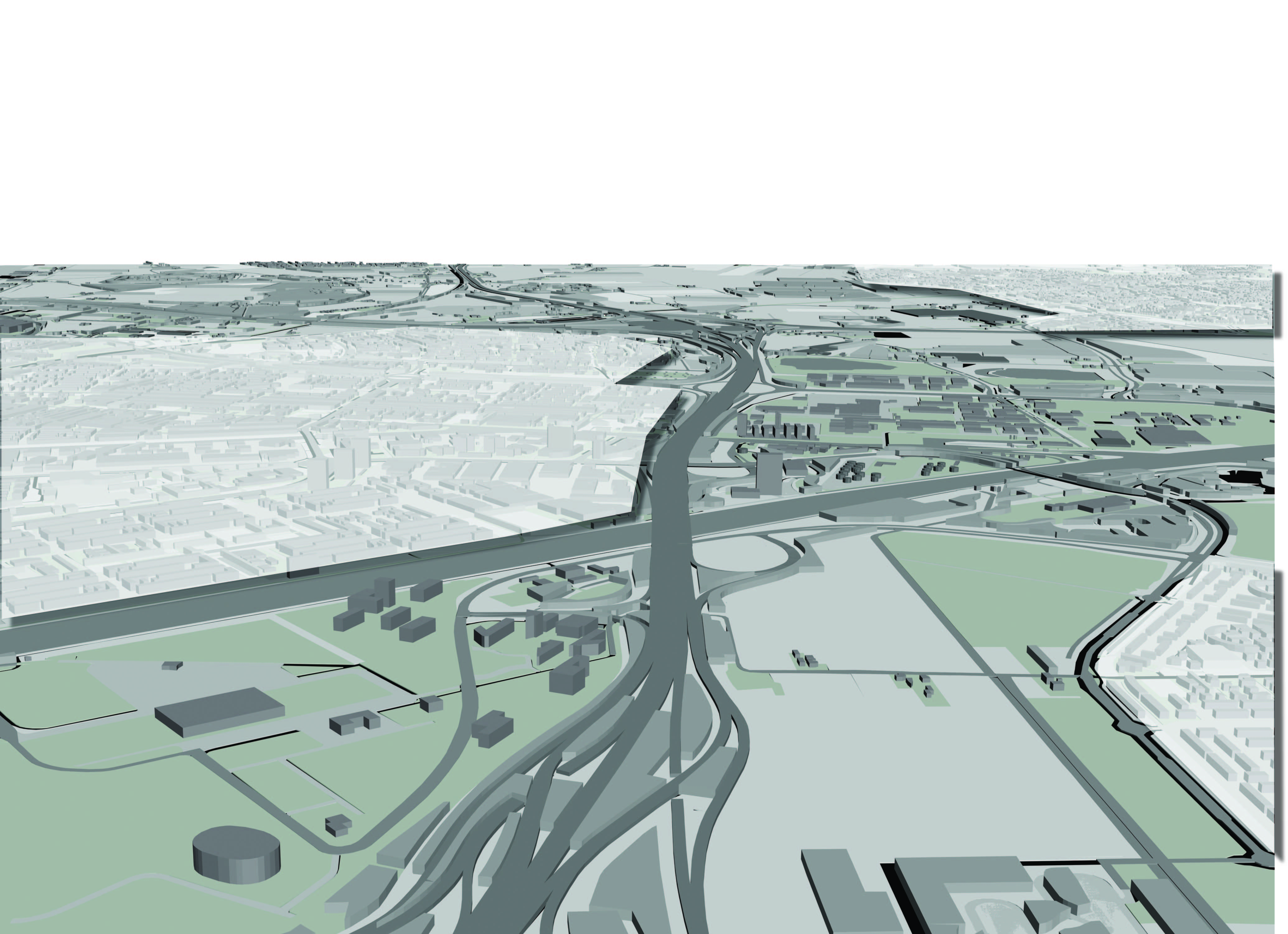
Entering the Randstad zone from the east, the conventional set of landscape images from the direction of the Utrecht hills is replaced by another set of images in the zone adjacent to the city of Utrecht. A vast field made up of infrastructural space and greenery interspersed with office buildings, warehouses, furniture halls, car showrooms and billboards flank the motorway on either side [Fig.8].

Fig. 8. The motorway landscape of the A12 zone.
The zone is for all intents and purposes urban but the spatial experience is not. The effect is qualifiable: viewed from the elevated highway vertical elements set off against an omnipresent horizon, contrasting with an urban interior defined by a skyline of buildings. The effect is also quantifiable: seen in terms of area the built form represents only 15% of the total highway zone. The phenomenology of the A12 zone demonstrates the shift of metropolitan transport networks beyond both the morphology of the natural landscape and the architecture of the city. Here, infrastructure has become self-sufficient, taking up ever more physical space and becoming visually dominant. The nodes in this network – structural works and roundabouts, intersections with railways and waterways and the sculptural-looking buildings and ensembles of the motorway decor – are not directly bound to the rural and urban topography but constitute a new metropolitan topology. Kinetic perception, the metropolitan dweller’s movements by car, tram, train or airplane, and the perception of the urban landscape as it flashes by in visual episodes determine the basic landscape form of metropolitan infrastructure – a space of flows.
How the landscape is perceived depends on the way the route engages the natural, urban and cultural landscape. The motorways of Holland make their way with maximum efficiency through the dense cultural landscape. Agricultural lots are laid out at right angles whenever possible to minimise the loss of land. In the reclaimed polders the road is set low and straight; at their edge it rises to adopt a direction towards another polder where the most expedient direction is often not on axis with the existing stretch. These alignments must be reconciled – hence the gentle curves designed into the route. Often, in the straight lines we can recognise the upright elements of formal staging such as viaducts, sight lines to towers or chimneys and the sometimes rigid lines of poplars.
When in the landscape of the infrastructural networks we can recognise an architectural staging, as in the deliberately picturesque moment of a sudden view or the formal staging of coulisses, we can call this movement space a flowscape. The flowscape is the landscape-architectural staging of the urban machinery in motion; as such, it arranges the urban field in accordance with the mobility scenario of the metropolis. It is in fact an extension of the principle of the route as a basis for a succession of ‘scenes’, a landscape as perceived while in movement, as in the 18th-century landscape garden.
The locomotion is motorised and en masse; just as the ‘scenic drive’ threaded through the landscape garden, so the motorways of today wind like human rivers though the urban landscape. The grand scenic parkways, built in the 1930s in the United States, recreational motorways interconnecting parks and park areas into a coherent system in such a way that motorists could enjoy nature while in transit, made the translation from the landscape garden into the urban realm. The roads were often designed to respond to the natural contours and cross traffic was carried overhead by rustic bridges, making the act of driving itself pleasurable. Panoramic views were afforded from various look-out points. (( Christian Zapatka, The American Landscape (New York: Princeton Architectural Press, 1995), p.121. )) A similar accent on the narrative aspect of the road can be found in the designs for the expansion plans for Rotterdam (Witteveen, 1928) and Amsterdam (van Eesteren, 1935), and Neutelings took it even further in his study of the Ring road of Antwerp (1988) by describing the road as a functionally and visually autonomous urban space. (( Willem-Jan Neutelings, ‘Ringcultuur’, Vlees en Beton, 10 (1988). )) [Fig.9]

Fig. 9: Flowscape: Project Neutelings W.J., ‘Ringcultuur’.
Plantation
Beyond the flanks of the A12 lies a constellation of urban concentrations. In the rolling screenplay of the Randstad-motorway ‘road trip’, these urban concentrations appear as low stripes briefly interrupting the horizon. Using other metropolitan networks, the metropolitan resident passes through these areas, revealing interiors defined by programmatic zones of housing, work areas and recreation facilities. [Fig.10]
Fig. 10: Urban concentrations along the A12 zone.
The fabric of these territories is defined by the programmatic demands of each land use: suburban subdivisions, industrial and office park allotments, lakes, forests and parks. These fabrics are essentially thickenings of a surface: a 3-dimensionalisation of a programmatic plan figure.
Existing and future urban programmes are the mechanisms for organising the colonisation of the urban field. These programmes lay down rules for the physical environment that give rise to regular patterns (grids) placed upon the existing natural and cultural landscape, with similar ordering principles for urban programmes like dwelling, work and leisure (as regards plot subdivision, dimensions, form and alignment) and programmes geared to intensive cultivation, such as forestry and glasshouse horticulture. In its basic form this harks back to land reclamation, the colonisation of the cultural landscape and the rational pattern of the 17th-century Dutch town. If the programme of the urban colonisation grid is staged in landscape-architectural terms, and the interaction between grid and the existing natural and cultural landscape is expressed in the design, we can call this second basic form of spatial landscape a plantation. The term plantation evokes associations with markets and production, and denotes that the underlying landscape has been technically modified. The basis for spatially organising the urban programme is an imaginary rational grid of squares laid over the existing landscape. The grid module derives from the dimensional characteristics of the urban programme but is carefully balanced against the grid dimensions of the cultural landscape. This landscape gains architectural expression in the interaction of new grid and existing landscape. This in turn gives rise to urban and rural fragments with an active role to perform and enable, together with the plantation, a new compositional equilibrium. Ellen Marcusse’s design for Almere-Hout, a district of the Dutch city of Almere, is based on an unpredictable trade-off between a simple urban grid and an invisible landscape layer composed of the many archaeological sites in the plan area, the former bed of the Zuiderzee. Holes are to be scooped out of the urban fabric to receive public gardens at key archaeological sites to enable future excavations here. The locations of these sites is as yet unknown, so that the resulting pattern has a major element of unpredictability built in. [Fig. 11]

Fig. 11: Plantation.
Theatre
The urban-landscape continuum of the metropolis puts an end to the ‘edge-of-the-city’ condition where the (open) landscape is traditionally apprehended.
In the metropolitan territory the ‘space’ of landscape; indefinite, contained or endotic – must be had within the bounds of the urban field. Lerup opens his book Beyond the City with a description of Houston’s urban area as a ‘mottled plane … crude and wild, marked by fissures, vacated space, and bits of untouched plain’. He relates Houston to Smithson’s analysis of New Jersey 30 years earlier: ‘(Passaic) seems full of “holes” compared to New York City, which seems tightly packed and solid, and those holes … are the monumental vacancies that define, without trying, the memory traces of an abandoned set of futures.’ (( Lars Lerup, After the City (Cambridge: MIT Press, 2000), p. 32. )) The edge of the metropolis – as even the largest conurbation does end at some point – can be considered as an edge-of-the-city moment only for those lucky enough to live near it. In the case of the Randstad and Los Angeles the sea forms the most abrupt and definitive edge-of-the-city moment. Within the metropolis, topographic ‘lesions’ in the metropolitan fabric such as the slag heaps of the Ruhr or Monta Stella in Milan function as surrogates for the edge-of-the-city experience: the viewer temporarily withdraws out of the spatial confines of the city and views that selfsame city as landscape – using the spatial and visual ‘devices’ of landscape to perceive the city. In the absence of major topographic ‘lesions’ – as is the case of the Randstad – the apprehension of landscape space is restricted to voids within and between urban tissue. In the A12 zone these voids are the unintentional results of environmental legislation and zoning conflicts. Relief from the congested space of the plantation can be found in the primordial space of these derelict gaps. Swimmers flock to sand depletion lakes; birdwatchers to polder relicts. [Fig.12]

Fig. 12: Landscape voids along the A12 zone.
Spatial quality in the voids along the A12 is at best accidental; the composition of a void necessitates firstly recognition of its existence and then potential. When this occurs we can speak of the existence of a third basic landscape form – the landscape theatre.
These open spaces hark back to Smithson’s description of the holes in the urban fabric, ‘the monumental vacancies that define, without trying, the memory traces of an abandoned set of futures’. The theatre can be seen as the counterpart to the programmatic excess of the plantation, where the city-dweller stands face to face with natural processes, the ‘longue durée’ of evolution and natural growth, silence and emptiness. Here the horizon of the landscape is inverted towards an inner horizon in the urban domain. This spatial ‘staging’ of the panorama, the ‘scene’, refers to the staging in a theatre, a landscape theatre. The landscape theatre is conceivable at every scale within the panoramic range. The landscape theatre is used in the definition of metropolitan form in Deltawerken 2.0, the graduation project of Ronald Rietveld for the Amsterdam Academy of Architecture in 2004. To direct the urban growth of Arnhem en Nijmegen a void of 3000 ha has been secured within the small-scale urban landscape for an area between de Rhine and Waal rivers. The design targets a flood bypass proposed by the national water authority to counter the threat of peak discharges from the Rhine and the Waal. This civil engineering intervention comprises an empty bypass, which is expected to fill every 20 years with excess water from the rivers. A 200-meter wide dike planted with 50,000 elms contains the void. [Fig. 13]

Fig. 13: Landscape theatre: Deltawerken 2.0
Returning to Banham’s study of Los Angeles – in which the contextual settings are described as atmospheres or psychological realities – we can recognise the basic forms in the metropolitan fabric. The freeway system is not only a way of living, but a flowscape with its own form, separate from the urban grid and with a three-dimensionality derived from necessity, providing a sequence of views related to being above the cityscape with panoramic views or being within and being part of it. The city itself has the character of a plantation with the diagrammatical structure of a matrix that can absorb and generate an unlimited number of functions and programmes. The urban coastline, over 100 kilometres in length, curves inland between two rock formations, where it forms a water stage and a recreational surface of 40 kilometres in diameter.
The landscape functions as an open space, a landscape theatre, in the metropolis, a new metropolitan form, introducing the natural form and the landscape scale as self-evident components of the city.
Ordering and composing the metropolis
Flowscape, plantation and landscape theatre can be regarded as landscape-architectural basic forms of the metropolis. However, these basic forms, applied as equal components distributed in response to programmatic needs, will still lead to a diffuse, fragmented and disorienting environment. ‘Described here as complete and more or less self-contained landscapes, in reality they are impossible to distinguish geographically. In the villa landscape [that developed from the Renaissance onwards], with its intense relationship between villas (plantations), the view across the open landscape (landscape theatre) and the transport arteries formalizing the urban territory (landscape of flows) we can see how an ingenious interplay between the prototypes can breach the scales defining the landscape and endow that landscape with architectural form.’ (( Saskia de Wit, ‘Layered Lowlands’, in: The Architecture Annual 2003-2004, ed. by D. Hauptmann and H. Wanders (Rotterdam: 010 Publishers, 2005), p. 116. )) As in the villa landscape, basic forms in the metropolitan landscape need to be embedded in a composition or structure that addresses fragmentation and disorientation, but without relapsing in the hierarchy-based organisation of the traditional city that has proven inadequate for the metropolitan condition.
The potential basis is the landscape: permanent, neutral and ubiquitous. Thus the composition of the metropolis as a landscape-architectonic problem has two levels. The basic forms are derived from the landscape-architectonic treatment of the (urban) landscape, the theory and history of composition, but the way they come together is again based on the physical landscape itself, the geomorphologic constant and unlimited substructure.
Landscape as redeemer of contemporary urban territories is a notion that has preoccupied designers and planners for the last two decades. Its attraction to planners and designers is understandable, not in the least because devices to comprehend and drive contemporary urban environments are becoming scarcer. The composition of new urban territories is increasingly reduced to the organisation of surfaces and infrastructures, by-and-large replacing the architectonic repertoire of city design of compact urban environments. In the urbanism discourse, landscape has moved beyond its traditional meaning as pastoral scenery or garden planting and now engages spatial problematique in urban territories under the umbrella of Landscape Urbanism. (( Landscape Urbanism is a term coined by Charles Waldheim. Charles Waldheim, The Landscape Urbanism Reader (Princeton Architectural Press, 2006). )) In its ‘coming-of-age’ landscape is less a quantifiable object than a way of seeing and doing. Landscape Urbanism repositions landscape in a broader sense as a large-scale organisational tool and thus relevant to the contemporary city. It cites the subject and practice of landscape above and beyond what is conventionally considered as landscape: the ‘antithesis’ or respite from the urban condition, contained within it but not a part of it. Landscape is championed as a device to regain meaning in this new reality: in the flat, extended non-city, landscape is the last relevant ‘ground’ for development. Landscape Urbanism sees surface as a defining tool in the choreography of the city. Surface here is understood as more than a formal or aesthetic working of the ground: the surface is seen as an agent of urbanisation. This means that the ground is prepared with the specific intention of organising future urban programmes or of being completely appropriated by them. Moreover, landscape is increasingly employed to comprehend and order urban development, because they have come to resemble each other: the city now changes, transforms and evolves as a landscape. Landscape can be instrumental as a tool in thinking about territories, in understanding larger spatial phenomena invisible to the eye of architecture and urbanism. Landscape Urbanism positions landscape as an infrastructural device – a medium through which all things must pass.
As shown above, this notion of landscape as an organisational tool for the composition of the metropolitan territory itself is not new. It has been part of the urban design history throughout the evolution of the metropolis, but it should be redefined in the light of the new task at hand. What compositional tools has the landscape to offer? If continuity and hierarchy can be said to be replaced by contiguity, then, as Steenbergen, Reh and de Zeeuw posed in their theory about the urban transformation processes, ‘the montage concept seems appropriate to connect the fragments of the urban landscape in a meaningful manner […] since it no longer aims at a harmonious connection of disparate parts, but can stage completely opposite or even contradictory urban programmatic parts landscape-architecturally, by means of stacking and confrontation. In the montage the architectonically active parts of the existing landscape are as it were, prepared and inserted in a new composition at a different scale.’ (( ‘Het montageconcept lijkt geschikt om de fragmenten van het stadslandschap zinvol met elkaar te verbinden […] omdat het niet langer streeft naar een harmonische verbinding van ongelijksoortige onderdelen, maar volstrekt tegengestelde of zelfs tegenstrijdige stedelijke programma-onderdelen landschapsarchitectonisch door middel van opeenstapeling en confrontatie kan ensceneren. In de montage worden de architectonisch werkzame delen van het bestaande landschap als het ware uitgeprepareerd en ingezet in een nieuwe compositie op een andere schaal.’ Clemens Steenbergen, Wouter Reh, Peter de Zeeuw, Landschapstransformaties (Delft: Delft University Press, 1995), p. 74. )) But how can we see this so-called montage in a physical, visual and spatial sense? The landscape as an informant of this metropolitan composition provides several motives leading to different models. A first motive is the structure of the existing landscape, built up through the ages from the geomorphogenetic system of mountains, rivers and oceans, formed by the forces of nature, of land, water and wind, and transformed by the processes of cultivation and of civil engineering. (( Saskia de Wit, Dutch Lowlands: Morphogenesis of a Cultural Landscape (Amsterdam: SUN Publishers, 2009). The theory of the form of the landscape is developed by the Chair of Landscape Architecture. )) This motive would lead to the geometric model of the landscape as substructure or framework. A second motive is the landscape space, often – especially in a dense country like the Netherlands – used in a conservative manner, to ‘preserve the open landscape’, but with a potential to serve as a spatial model, dictating the position of the landscape theatre as opposed to the plantation. The conceptual discourse on the relationship between the metropolis, the city and nature can be seen as a third motive for the staging of a landscape-urban composition. While the notion of city is inherently directed towards artifice and the absence of natural forms and processes, the metropolis on the other hand points in the opposite direction, towards an innate and non-hierarchical relationship between artifice and nature. (( Lars Lerup, After the City (Cambridge: MIT Press, 2000), p. 23. )) This is the basis for the third model, where the landscape takes a narrative position: the landscape as specific place or territory, a provider of meaning, grounding the generic system of the metropolis.
If we look again at Banham’s study of Los Angeles we can recognise not only the basic forms in the metropolitan fabric, but the contours of the landscape models that determine the composition of metropolitan landscape. The continuous urban field of some 10,000 square kilometres also encompasses the hills situated in the plain like a gigantic tribune. Seen from here, the city is reduced to a geographical texture, with the ocean as a hazy backdrop. The urban footprint appears as a city that is, at the same time, a landscape; a metropolitan landscape. The distinct topography of coast, hills and central flatlands is the carrier of the metropolitan structure, the transformation of the generic Jefferson grid into a unique city. In principle this metropolitan landscape encompasses the entire space; it is generic and unlimited until it encounters an insurmountable physical geographical barrier such as the ocean. Here the supergrid collides with primal nature, with Sunset Boulevard as a new active scenography of this confrontation. The spatial qualities and the scale of the landscape have been introduced as a landscape space within the metropolis, the space of the ocean, enhanced by the way it is overlooked by the different levels of hills, plain and boulevard. Thirdly, in the well-known images of the beautiful white sandy beach, the endless plain with its supergrid and the delectable mountains of Hollywood, Beverly Hills, Bel Air and the like we can detect the landscape as an indicator of place, complementary to the generic character of the metropolis, taking up a narrative position, a giver of meaning.[Fig. 14]

Fig. 14: Choreography
Narrative places can be nodes in the metropolitan galaxy, defined places in a continuous field, not expressing the spatial-temporal continuum of the metropolis, but discontinuities in it, anchor points to the landscape topography that connect the generic network of the metropolis to the genius loci. Narrative places can be viewed as rhetorical landscapes; they are made of the same materials as all the rest, just as the rhetorician’s words are those given by the language, but composed to ‘instruct, move and delight’ (Cicero’s definition of the rhetorician’s duties). With some affinities to metaphor in literature, they are places where the relationship of things is so moving or so clear that the rest of the world is illuminated for us. These places evoke their origins, are an expression of the genius loci. The term ‘genius loci’ is derived from the Romans who read places like faces, as outward revelations of living inner spirit. Each place had its own individual Genius – which might manifest itself, on occasion, as a snake. (( Charles Moore, William Mitchell and William Turnbull, The Poetics of Gardens (Cambridge, Mass: MIT Press, 1988), p. 49. )) Such spaces are indissolubly bound to the (urban) tissue, and at the same time they are essentially ‘other spaces’, contrary to their surroundings, ‘in such a way as to suspect, neutralize, or invent the set of relations that they happen to designate, mirror or reflect.’ (( Michel Foucault, On Other Spaces (unpublished, 1967), p.3. ))
The play between the city and the landscape is resulting in metropolitan compositions at very different levels and the interaction with the landscape generates spatial forms on very different scales. Where the case of Los Angeles exemplifies the way the three models can co-operate to construct a metropolitan composition of plantation, landscape theatre and flowscape on the scale of the metropolitan region, we would like to compare this with an example of a metropolitan transformation on an much smaller scale: the transformation of Hampstead Heath from common ground to Metropolitan Park. Already in the Middle Ages London became a ‘scattered city’, a city outside its perimeter, existing of several townships. In the early 19th century John Nash made his ‘Grand Design’, as an expansion plan for London, meant as the completion of the ‘metropolis’, the rehabilitation of the visual contact with the surrounding landscape and an attempt to make space for the modernising of urban public life. The ‘Theatrical Panorama’, with Regent’s Park as the core, was used as a major design tool. (( Wouter Reh, Arcadia en Metropolis: het Landschapsexperiment van de Verlichting (Delft: Publikatieburo Bouwkunde, 1995), p. 405-416.)) Parallel to this Grand Design, the layout of London has gathered, more or less consciously, around similar landscape cores: royal hunting parks or common grounds, carriers of the metropolitan structure.
One of these cores is Hampstead Heath, with its openness to the natural elements and to the sky, whose moods the land merely reflects, a prototypical landscape theatre. The enormous impact Hampstead Heath has on writers, poets, painters and philosophers is an indicator of its quality as a metaphorical landscape, a place with a strong narrative impact. Since the Middle Ages the heath was used as common land, for grazing, gathering and digging. Over time the accent in appreciation shifted from its natural resources via its military value as a commanding height near London and manoeuvring site, its value for health and outlook, and finally for its own scenery and the possibilities it offered to escape from noise and dirt to one of the few remaining ‘lungs of the metropolis’. This resulted in 1871 in the Hampstead Heath Act, authorising the Metropolitan Board of Works’ purchase of nearly all that survived from the original common. (( C. R. Elrington (Ed.), A History of the County of Middlesex: Volume 9 (Hampstead, Paddington: Victoria County History of the Counties of England, 1989), pp. 75-81. ))
On the edge of the heath lies Hampstead Heath Garden Suburb. This suburb, designed by Raymond Unwin and Barry Parker at the beginning of the 20th century, was one of the first green suburbs and has been of great influence on the development of suburban housing. Suburbs like these are ultimately metropolitan in the sense that ‘each family home becomes the central point for its members. They create their own “cities” out of the destinations they can reach (usually travelling by car) in a reasonable length of time.’ (( Robert Fishman, Urban Utopias in the Twentieth Century: Ebenezer Howard, Frank Lloyd Wright and Le Corbusier (New York: Basic Books, 1977). )) The pattern formed by these destinations represents the city for that particular family or individual, a city based on time rather than space or distance, where each destination is measured in minutes instead of miles. On the other hand Hampstead Heath Garden Suburb is firmly anchored in landscape space. The different layers of landscape-architectural intervention, as seen in the position of the heath in the urban tissue of London, are in a condensed way expressed in the boundary between heath and the suburb. The boundary is both the condition to create an autonomous space, an ‘other’ space, as the connection to the outside, a reflection of the world on the other side. Hampstead Heath Garden Suburb exemplifies the definition of the boundary as an expression of the relationship between landscape theatre and plantation. In the oldest part of the suburb the homes are separated from the heath by a wall. Garden pavilions and sheds are embedded in the wall like medieval watchtowers. Only where one of the main streets of the neighbourhood emerges on the heath, the wall opens up to give pedestrians access to the heath. Southwest of the Great Wall are the first extensions of the quarter, and here an opposite approach is chosen. The homes are grouped around closes that open up directly to the open space of the heath. Height differences and low walls articulate the closes clearly as independent collective spaces pulling the landscape space of the heath into the suburb.(( Dick van Gameren, Revisies van de Ruimte (Rotterdam: NAi uitgevers, 2005), pp. 114-115. )) [Fig. 15]

Fig. 15: Choreography
Choreography
The case of Hampstead Heath illustrates the development of unique and specific topologies made possible by the ‘drawing-near’ of the metropolis to nature. The enlargement and distortion of specific topographies result in a field of new topologies, drawn from the genius loci and from local cultures and customs. The lack of hierarchy, not only in artifice and nature, but also in a spatial sense, implies that meaning is no longer derived from the structure or centre as in classical urbanism, but is borrowed from the characteristics of place. Judgements on the lack of compositional quality – contiguity – in metropolitan territories are also determined by the same classical urbanism sensibilities. When the city disintegrates into an archipelago of fragments a new role is imposed on the landscape as a carrier of topographical characterisations, cohesion and continuity. In the metropolitan territory the role of the landscape is of equal importance, regardless of programmatic, spatial or geographical differences. In the traditional dialectic landscape-city the countryside is omnipresent, and concurrent with landscape; the only design problem is safeguarding it from the land-hungry city. In the city on the other hand, other mechanisms (the urban programme) determine form. Landscape does play a role as an underlying structure and physical determinant, but is not a spatial and visual reality. Spatially, visually and rhetorically the city is considered a counterpart, an opposite of the landscape. In the metropolis other mechanisms may be dominant (networks), but they are so generic and abstract that they do not have the means to generate physical environments. The landscape has the capacity to inform the transformation of the physical metropolitan territory without contradicting the functioning of metropolitan mechanisms. The question is not so much if metropolitan form is determined by landscape, but how we can use it to structure and give meaning to territories: a delicate choreography of mega-shapes and the micro-topography of landscape places.